

Rainbow Bridge Trail
“Though its "discovery" by the outside world was only a hundred years ago, people native to the area have known about Rainbow Bridge for centuries. It is also quite likely that prospectors, ranchers, and others happened across the bridge in their wanderings. For many indigenous peoples in the Four Corners region, Rainbow Bridge is a spiritually occupied landscape that is inseparable from their cultural identities and traditional beliefs.”

Easy
From Boat Dock: 2.4 miles (3.9 km)
Hiking
Lake access requires boat trip
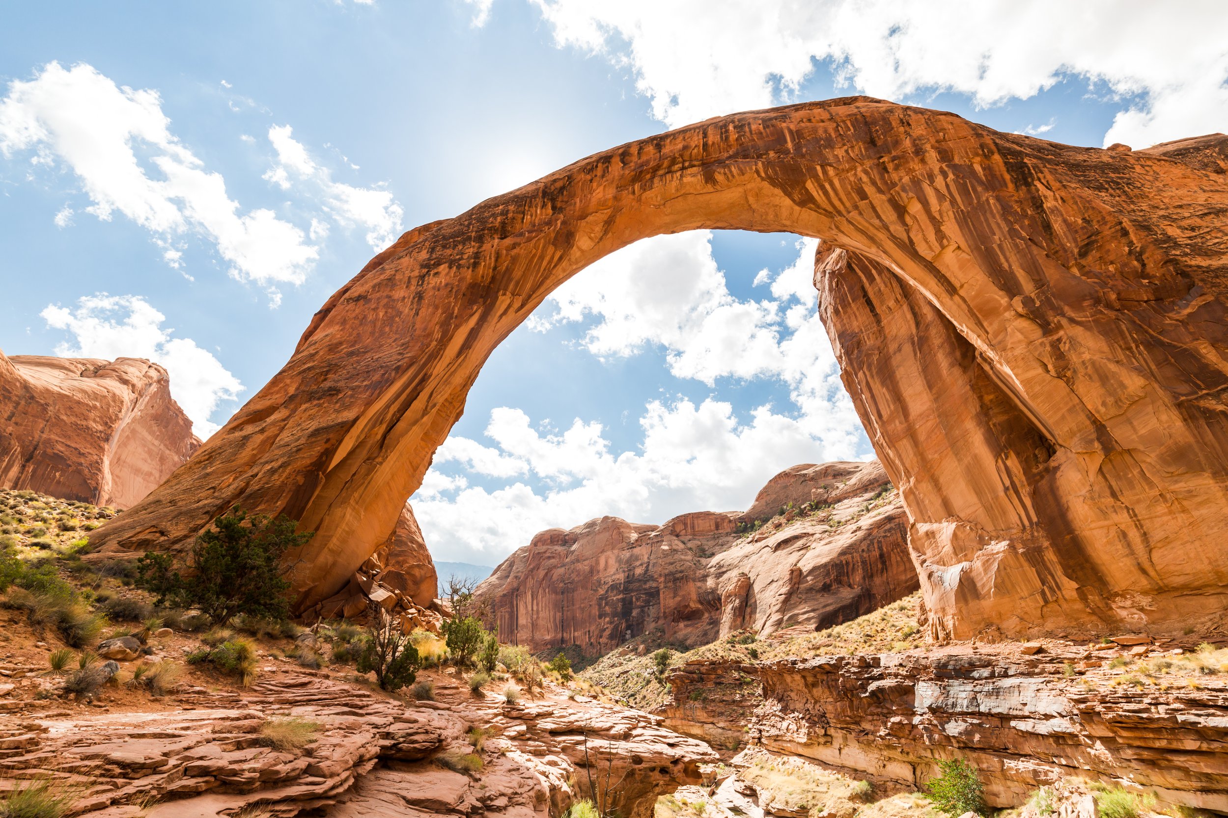
Rainbow Bridge is one of the world's largest known natural bridges. The span has undoubtedly inspired people throughout time--from the neighboring American Indian tribes who consider Rainbow Bridge sacred, to the 85,000 people from around the world who visit it each year. Access and the trail is managed by Glen Canyon National Recreation Area and Rainbow Bridge National Monument. Most visitors may arrive via boat to the park's courtesy dock, available for short-term docking. Floating docks, walkways, and restrooms have been re-anchored at the back of the canyon providing access to the Rainbow Bridge trail. Visitors will enjoy an approximately 2.4 mile (1.9 km) round-trip hike (depending on lake level) to the national monument. Hiking beyond Echo Camp requires an advance permit from Navajo Nation Parks & Recreation.
Rainbow Bridge National Monument - National Park Service (NPS)
GET THE APP. GET THE MAP.®
Download the Avenza Maps App and create an account. It’s free!


Directions
Rainbow Bridge is only accessible by boat on Lake Powell or by land over a 14+ mile trail from the Navajo Nation (advance permit required).
By Boat: Trips to Rainbow Bridge may be made across Lake Powell in Glen Canyon National Recreation Area using private, rental, or tour boats. From Wahweap or Antelope Point travel north. From Bullfrog or Halls Crossing, travel south.
Proceed to the mouth of Forbidding Canyon (buoy 49), where a floating sign on the right marks the canyon entrance. Follow the canyon about 2 miles (4 km) to another sign that points the way left through a narrow passage. Proceed with caution! Beyond the wakeless buoys, go slowly so that no wakes, or waves, are made.
Trail Details
Trailhead Coordinates: Wahweap Marina 36°59'33" N 111°28'52" W
Trail Access: There is an entrance fee for Glen Canyon National Recreation Area, from which visitors can access Rainbow Bridge by boat. Trail access from Lake Powell is managed by Glen Canyon National Recreation Area - Rainbow Bridge National Monument.
Trail Surface: Sand, hilly
Trail Condition: Minimally developed
Trail Use Type: Hiking
Best Season: March-May or October-November
Parking at Trailhead: Yes
Restroom / Water: No restrooms available after the dock / No water
Pet Friendly: No
Degree of Difficulty: From Boat Dock: Easy
Trail Type: Out and back
Trail Length: From Boat Dock: 2.4 miles (3.9 km) round-trip
Elevation Gain / Loss: From Boat Dock: 29 ft (8.8 m) ascending
Elevation at Trailhead: 3,753 ft (1,144 m) at Wahweap RV & Campground
Cell Service: No
Land Manager: National Park Service (NPS) - Glen Canyon National Recreation Area (GCNRA)
