


Other
Recreation Opportunties
Northern Arizona isn't short on recreation opportunities, whether it's on foot, bicycle, equine, or water. This section highlights more areas for exploration, with some that may be more off the beaten path or require more outdoor skills. Let this page, like the rest of the NAZTrails website, be your starting point in researching your next outdoor adventure.

Paria Canyon
The Paria River cuts through the Paria Canyon in northern Arizona, creating one of the longest and deepest slot canyons and offering views of outstanding desert scenery and desert wildlife. There are no marked trails. Primitive recreation opportunities for day-use hiking or overnight backpacking are available; permits required. Be cautious; there is flash flood potential.
-
Trail Access: Overnight and day-use permits required from BLM.
Trail Surface: Slickrock, sand, earth, clay. Hiking in river bed.
Trail Condition: Minimally developed
Trail Use Type: Hiking
Best Season: Spring and fall; flash flood potential especially during summer
Parking at Trailhead: Yes
Restroom / Water: There are four trailheads to access Paria River Trail, each with different amenities.
Pet Friendly: Yes, must be kept under control at all times and leashed within GCNRA and waste packed out.
Degree of Difficulty: Difficult
Trail Type: Through hike, or an out and back from Lees Ferry or any of the trailheads
Trail Length: 38 miles (61 km) one way
Elevation Gain / Loss: 1,130'
Elevation at Trailhead: 3,100’
Cell Service: Intermittent
Land Manager: Bureau of Land Management (BLM) - Grand Staircase Escalante National Monument
-
Visitors can access Paria Canyon from multiple points: Lees Ferry, Wire Pass, White House, or Buckskin Trailheads.
Coyote Buttes North (The Wave)
There are no established trails in this area. From the Wire Pass Trailhead, you can access two separate destinations, Buckskin Gulch or Coyote Buttes North (and The Wave).
Buckskin Gulch requires a day-use permit and can be paid at the site. Permits for Coyote Buttes North (The Wave), Coyote Buttes South, overnight use for the Paria Canyon, and Commercial use, must be obtained in advance, and are not sold at trailheads.
-
Trailhead Coordinates: 37°01'10"N 112°01'30"W
Trail Access: More info at The Page - Lake Powell Hub Visitors Center
Trail Condition: Minimally developed
Trail Use Type: Hiking
Degree of difficulty: Strenuous
Land Manager: Bureau of Land Management (BLM) - Vermilion Cliffs National Monument
-
From the intersection of Lake Powell Blvd. and North Navajo Drive in Page, the trailhead is 43 miles (69.2km) of which 8.3 miles (13.36km) is hard packed dirt road. The dirt road is impassable when wet. Drive north and west on Lake Powell Blvd., merge onto Hwy. 89 north.
Cross over Glen Canyon Dam. At mile 34.7 make a sharp left (south) onto House Rock Valley Road (dirt). The trailhead is 8.3 miles ahead on your right.
-
Visitors entering Vermilion Cliffs National Monument do so at their own risk. There are no marked trails, no drinking water sources, and only occasional contact with other visitors and BLM employees. Rescue may take hours or even days.
You are responsible for your own safety. Check weather, hiking, and road conditions before you set out. Be sure to carry extra water, food, and a first aid kit in case of emergency. Bring a map and compass or GPS, and know how to use them. Tell a responsible person where you are going, when you plan to be back, and who to call if you are overdue.
Cell phone in the Monument is unreliable. It is always worth attempting 911 in an emergency, but ther eis no guarantee.

Coyote Buttes South
There are no established trails in this area. This is a remote but beautiful area, and there is a lot of hiking in deep sand. You must have a four-wheel-drive, high-clearance vehicle.
-
Trailhead Coordinates: 37.1046°N 111.9003°W
Trail Access: More info at The Page - Lake Powell Hub Visitors Center
Trail Condition: Minimally developed
Trail Use Type: Hiking
Degree of Difficulty: Intermediate
Land Manager: Bureau of Land Management (BLM) - Vermilion Cliffs National Monument
-
-
Visitors entering Vermilion Cliffs National Monument do so at their own risk. There are no marked trails, no drinking water sources, and only occasional contact with other visitors and BLM employees. Rescue may take hours or even days.
You are responsible for your own safety. Check weather, hiking, and road conditions before you set out. Be sure to carry extra water, food, and a first aid kit in case of emergency. Bring a map and compass or GPS, and know how to use them. Tell a responsible person where you are going, when you plan to be back, and who to call if you are overdue.
Cell phone in the Monument is unreliable. It is always worth attempting 911 in an emergency, but there is no guarantee.
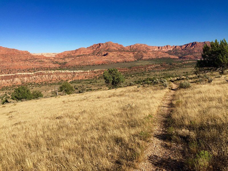
Arizona National Scenic Trail
Passage 43: Buckskin Mountain
The Arizona National Scenic Trail is a complete non-motorized path from Mexico to Utah, stretching 800 diverse miles across Arizona to link deserts, mountains, canyons, forests, history, communities and diverse peoples.
The Arizona Trail Association’s mission is to protect, maintain, enhance, promote and sustain the Arizona Trail as a unique encounter with the natural environment.
-
Trailhead Coordinates: Passage 43: Buckskin Route has two access points.
Southern Access: 36.91775° N, 112.10707° W
Northern Access: 37.00112° N, 112.03499° W
Trail Use Type: Hiking, Biking
Degree of Difficulty: Easy
Trail Length: 10.6 miles
-
This area features three passages of the Arizona National Scenic Trail, with north and south trailheads. For detailed trail descriptions, trail maps, and directions to trailheads, please visit https://aztrail.org/.

Horseback Riding and Helicopter Guided Tours
There are permitted outfitters with Navajo Nation Parks & Recreation that offer guided horseback tours to Horseshoe Bend and helicopter tours of the area. Check out the guided tour operators for more information.

Guided Services
for Paddlecraft, Fishing, Hikes, Photography, Land Tours, and Water-based Instruction
Glen Canyon National Recreation Area has permitted outfitters that offer guided fishing services, guided kayak/canoe services, guided kayak/stand-up paddleboard instruction, and backhaul services on the Colorado River. Check out the guided services for more information.

Various Activities
on Vermilion Cliffs National Monument and Grand Staircase-Escalante National Monument
If you're interested in exploring Vermilion Cliffs National Monument through outfitters and guides, visit for a current list.
For a list of approved outfitters and guides for Grand Staircase-Escalante National Monument, visit for more information.